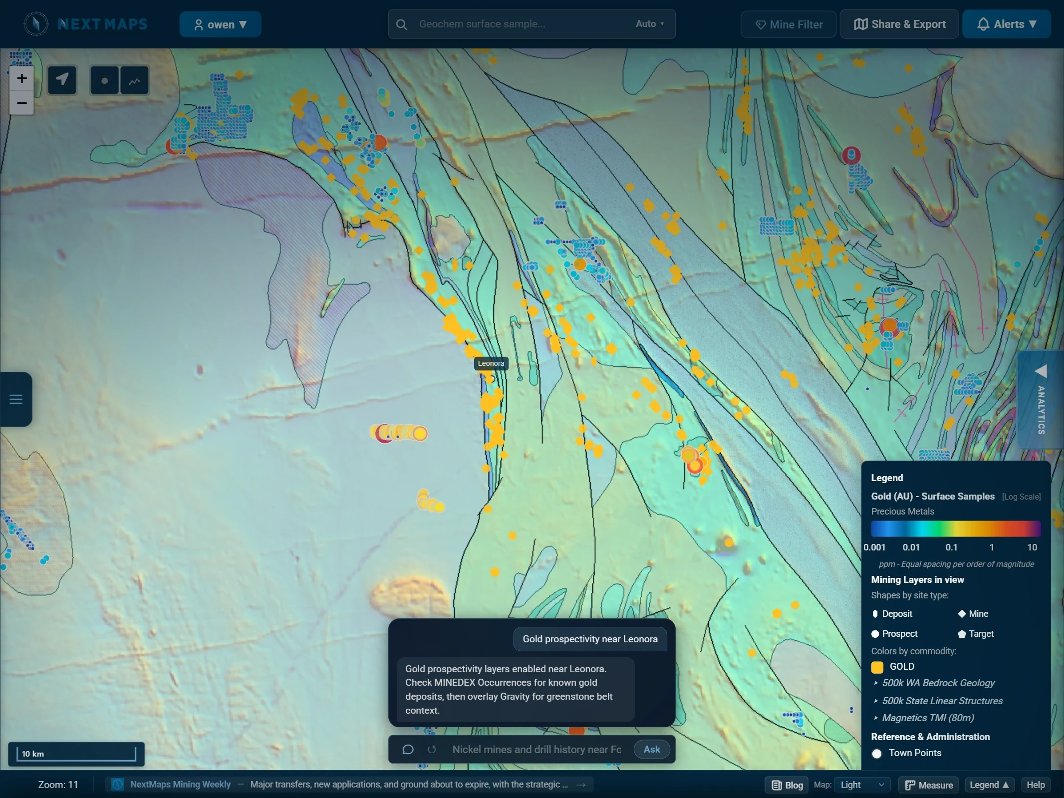
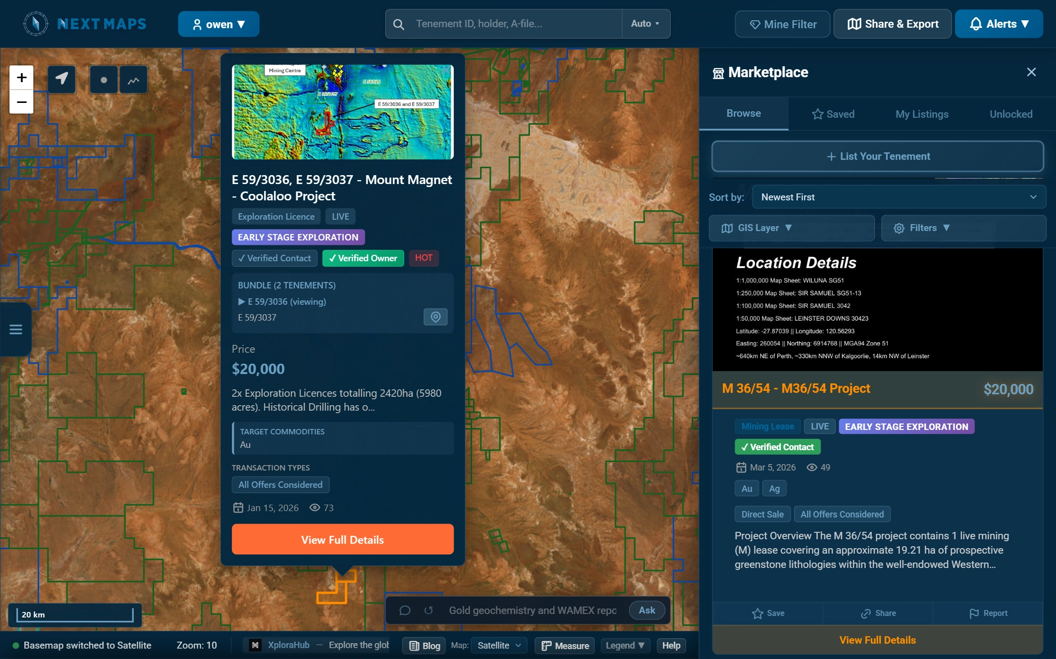
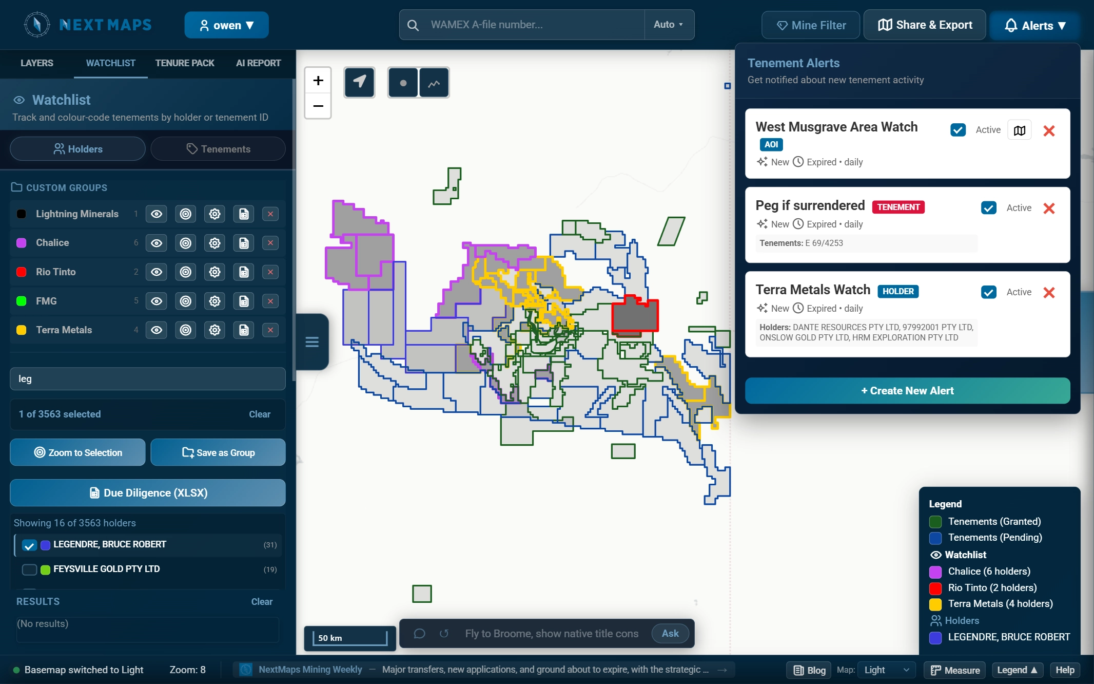
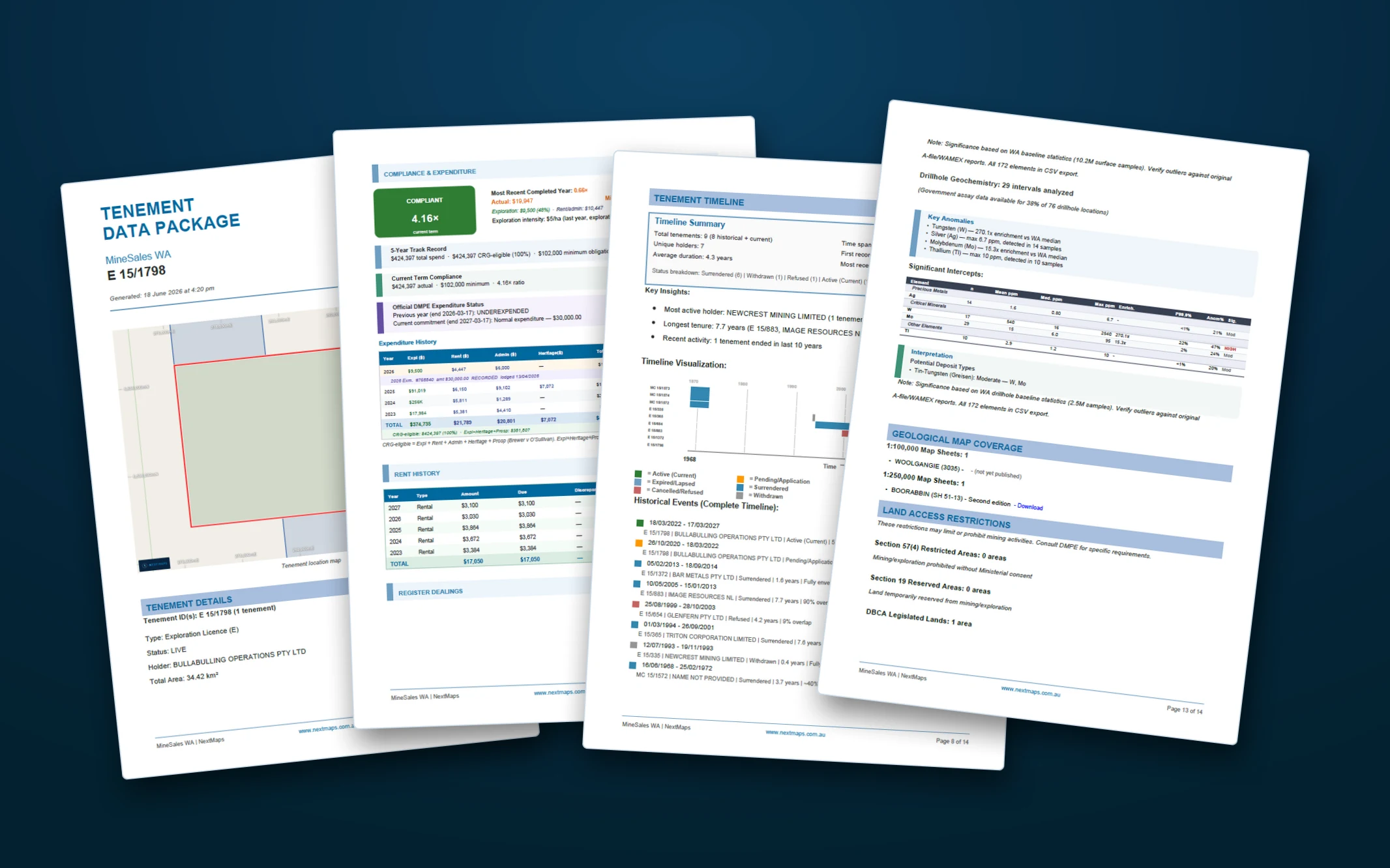
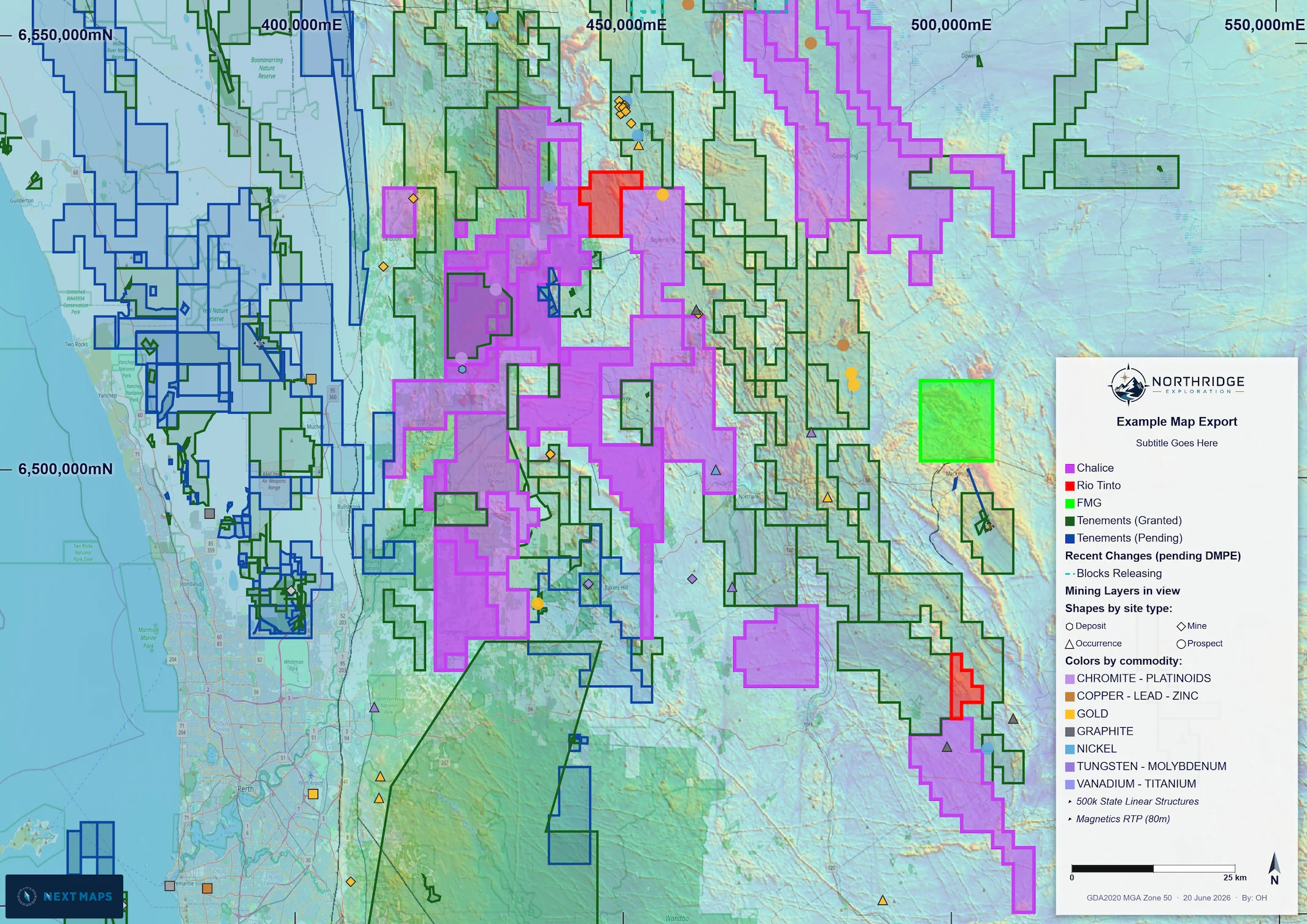
The WA exploration map

All of WA's ground on one map.
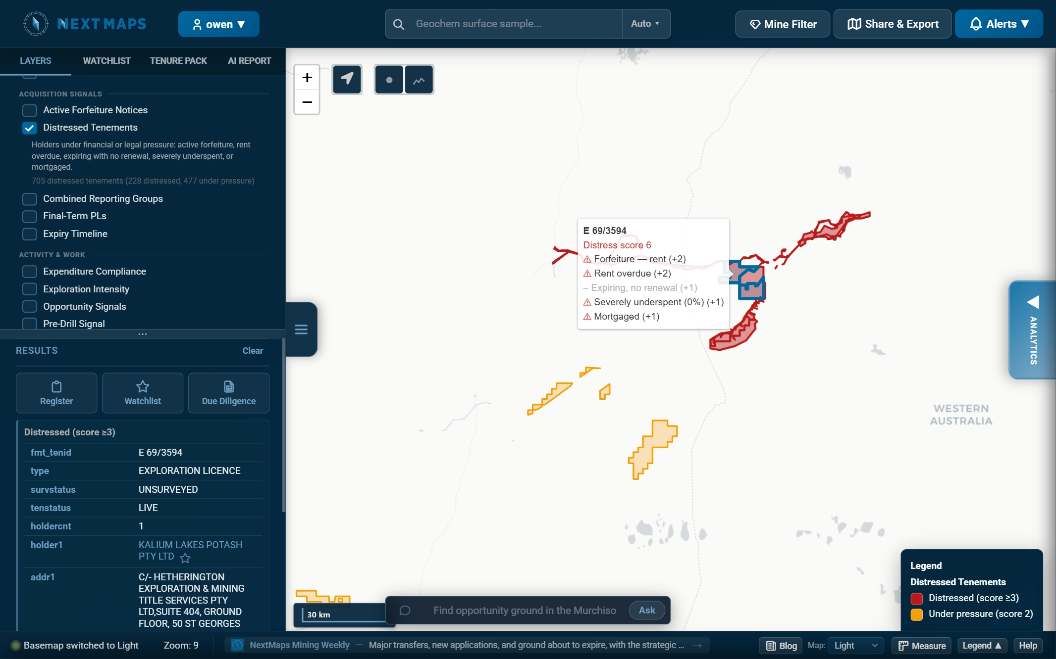
Risk and opportunity, unearthed.

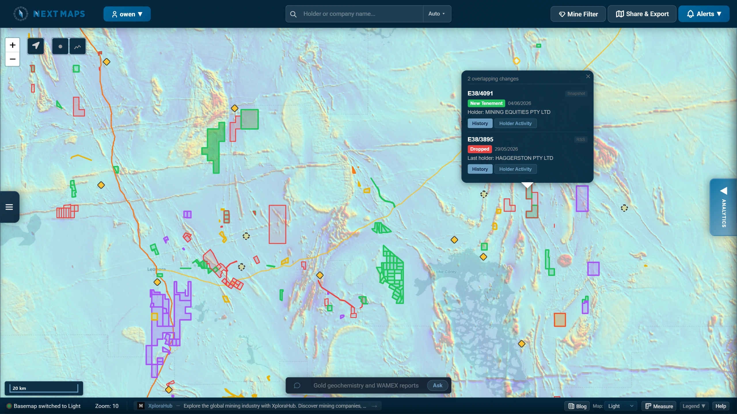
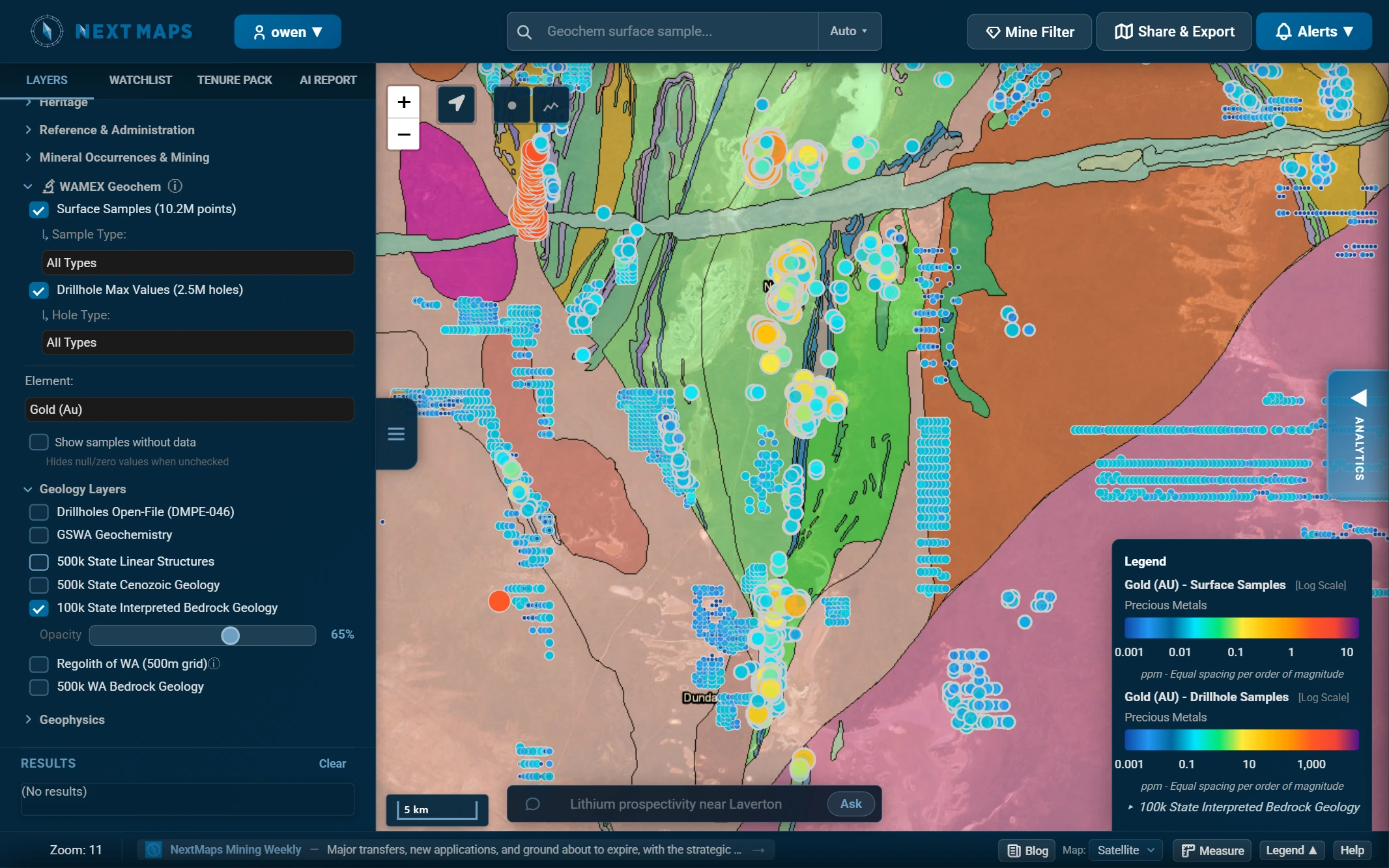
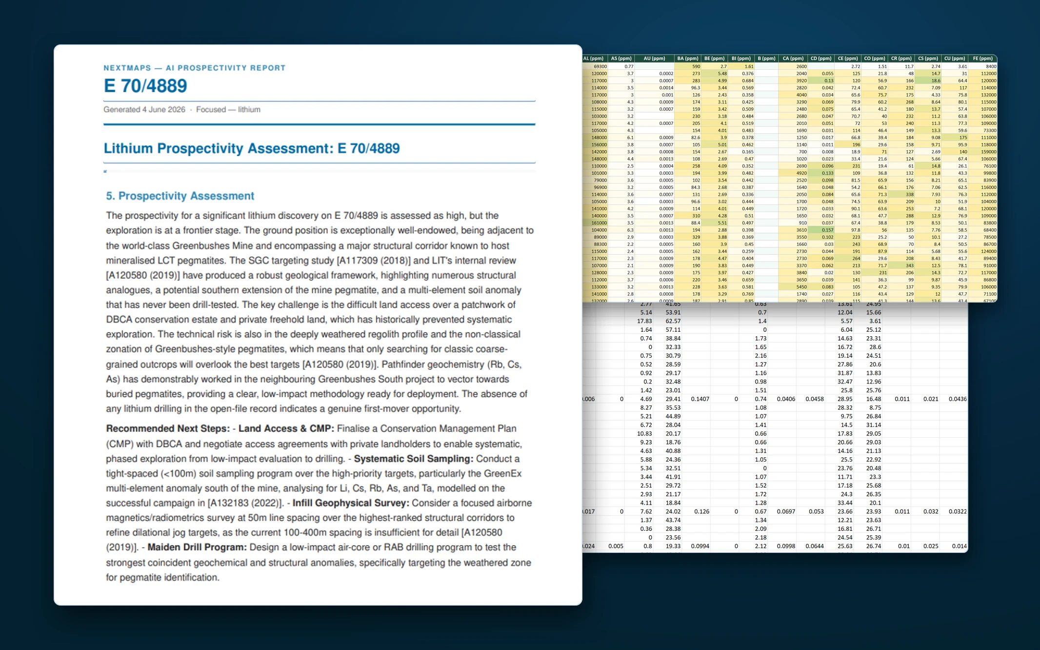
Tenure, geoscience and constraints unified on one live map of WA, with every change tracked and the signals scored for you daily, so you spot the pressure and the openings before anyone else.

Live SLIP and DMPE data, refreshed daily. Built for WA explorers, consultants and investors. Free to start.

The NextMaps live map of WA tenure, geoscience and intelligence, showing tenement timeline changes near Leonora
Map Intelligence AI reports Tenure Packs Alerts Marketplace Exports
Built on official WA Government data, refreshed daily: SLIP (Landgate)· DMPE· GSWA· DBCA· DPLH
The problem

The register holds the answers. Reading it is the work.

Everything you need is public. Pulling it together is the job that eats your week.

  • Decades of WAMEX reports sit on the ground you're chasing, and no one has time to read them.
  • A competitor's expenditure shortfall stays buried until the ground is forfeited.
  • Tenure, geology, geochem and constraints all live in different places.
MTO and TENGRAPH are free, but you do the reading. NextMaps reads it for you: tenure, geoscience and constraints on one map, monitored constantly, with AI that turns the WAMEX archive into an answer. That is what you pay for.
The most complete WA map

Every layer that matters, on one map.

Live and dead tenements, WAMEX, and the geoscience and constraint layers you would otherwise chase across a dozen portals.

10.2M surface geochem points2.5M drillholes70+ elements Magnetics, gravity, radiometricsBedrock & structures Native title & heritageLand accessMINEDEX & mines Search by tenement, holder, A-fileMine FilterYour own layers
The NextMaps WA map with the layer tree open and a geoscience layer enabled
Tenement Intelligence

It reads the register for you. See risk and opportunity first.

Derived daily from the WA register. Signals you can turn on over the map, on their own or layered together.

Tenement Timeline

Play WA tenure changes forward and back over time, and watch grants, transfers and surrenders unfold across the state.

Distressed Tenements

Holders under financial or legal pressure: forfeiture, overdue rent, severe underspend, expiring with no renewal.

Ground Release Zones

Where supply is opening up, ground lapsing or being surrendered, before it is formally gazetted.

Expenditure Compliance

Actual spend versus the minimum obligation, so you can see who is underspending their commitment.

Application Hotspots

Where ground is being contested, grid cells coloured by how many companies are competing.

Expiry Timeline

Every live tenement coloured by time to expiry, with the final-term PL licences that cannot renew.

Click any flagged tenement and the signal shows its working, scored, not guessed:
E 31/1289Distress score 5
  • Forfeiture, expenditure +3
  • Rent overdue +2
  • Expiring, no renewal +1
  • Severely underspent (8%) +1
  • Mortgaged +1
E 38/3402Opportunity 4 / 4
  • Underspent (31% compliance)
  • Low intensity (bottom 25% of type)
  • Long-held (since Mar 2014)
  • Rent lapsing, holder disengaged

Plus Recently Transferred, Ownership Age, Encumbered (mortgages and caveats), Forfeiture Notices, Conversion Pipeline, Pre-Drill Signal, Combined Reporting Groups, Exploration Intensity and an analytics dashboard.

The WA map coloured by a Tenement Intelligence layer
AI built for exploration

Read decades of WAMEX in minutes. Then explore the map by asking.

AI prospectivity reports

For a tenement or a drawn area, NextMaps reads the historical WAMEX archive into a referenced prospectivity assessment: geological setting, mineralisation controls, past programs, the grades and anomalies, and clear next-step drill targets, every claim cited back to its A-number. Delivered as PDF and Markdown, with the source archive and a data room.

An AI prospectivity report and data room

The Map Explorer agent

Type a goal in plain English and the map builds itself, layers, filters and all.

Gold prospectivity near Leonora Ask
The Map Explorer agent turning a prompt into a layered prospectivity map

Skip the desk study. Start unearthing targets.

Marketplace

Before you surrender it, sell it.

Non-core to you is not non-core to everyone. The window to recover value is while you still hold the ground, so list it before it lapses.

  • List the ground you're about to drop in front of explorers actively looking at WA tenure.
  • Once it's live, your listing is emailed straight to NextMaps' base of WA explorers, consultants and investors, not left to whoever happens to browse the map.
  • Your WAMEX record goes with it, so buyers get a documented head start, not blind dirt.
  • Sell outright, or list a JV or farm-in to keep an interest in the upside.
  • On the map, with an optional NDA gate. Contact is free, no lead fee.
A marketplace listing shown on the NextMaps map
Alerts and watchlists

Know the moment it moves.

Watch an area or a holder and let NextMaps tell you when ground changes hands or opens up.

  • Area and holder alerts by email: new applications, transfers, surrenders, expiries.
  • Colour-coded watchlists for the holders and tenements you track.
  • Pending-change enrichment that beats the gazette, plus the Mining Weekly digest.
A NextMaps alert email and the watchlist panel

Set it once. We'll watch the rest.

Tenure Packs & Due Diligence

The whole tenement, written up for you.

One click turns any tenement or area into a complete tenure pack: a written report, a structured due diligence workbook, and every spatial file, ready for the desk or the field.

  • A plain-English register synthesis: status, risk and opportunity scoring, ownership and transfer history, year-by-year compliance and expenditure, and every dealing in full.
  • A timeline of the historical ground underneath, plus WAMEX, drillhole and geochem summaries with anomaly analysis and deposit-type calls.
  • Land access, native title and heritage in one place, plus the due diligence workbook and full GIS files (Shapefile, GeoJSON, KML).

The report is delivered as a polished PDF and Markdown; the due diligence workbook is an Excel file with every holder, dealing, expenditure year, rent payment, condition, native title referral and bond laid out tab by tab.

Regenerate any pack on demand. It rebuilds against the live register every time, so you always have an accurate launching-off point for annual reports, ASX announcements and board packs.

View a sample tenure pack (PDF) Download an example due diligence workbook (Excel)
An example NextMaps tenure pack report
Share and export

Professional maps for your projects. Live, on your own site.

Export announcement-grade maps, embed a live map on your website, or share a view with colleagues.

  • ASX-announcement-quality map images and PDFs.
  • A live-data map, locked to the view you choose, embedded on your own site.
  • Share a map view with colleagues in a click.
An ASX-quality project map exported from NextMaps
The map below shows live NextMaps data, locked to the view it was published at. Drop one on your own site straight from Share & Export.

Everything you need to make the call, on one map.

Who it's for

Built for the people who move on ground.

Explorers

Spot open and dying ground early, get an AI prospectivity verdict and next steps from every historical report, and peg with the full history in hand.

Consultants & Tenement Managers

The whole map in one place, plus one-click due diligence and tenure packs to hand straight to clients.

Investors & Acquirers

Screen a company's entire portfolio, watch distressed and transferred ground, and acquire on the marketplace.

Owen, founder of NextMaps and a WA exploration geologist
Why it exists

I built the map I kept wishing existed.

NextMaps began as a cartography service, making the professional geological maps and figures that WA explorers put in front of their investors. But as an exploration geologist I kept hitting the same wall: hours lost stitching together government datasets just to peg my own ground and work out where the opportunity was. So I built the map I wanted, put the intelligence on top of it, and it grew from there.

That is still the test for every feature: would it have saved me a day in the field or a week at the desk. NextMaps reads the register, the WAMEX archive and the geoscience the way a geologist actually works, because one built it.

Pricing

Start free. Upgrade when it pays for itself.

Premium launches 1 July 2026. The full map and Premium tooling are free for everyone until then. From 1 July, Premium and Pro features move behind a subscription — you can subscribe early any time.
Free
$0

Everything GeoVIEW gives you, on a map that's actually fast to use. No card required.

  • Live tenement, WAMEX and geoscience layers
  • Multi-type search across tenement, holder and A-file
  • A cleaner, faster WA map than the government tools
  • Three free outputs to try the paid tools: a survey report, a focused commodity report and a datapack
Open the map
Premium
$50 / month

The intelligence layer and the full working toolkit.

  • Everything in Free
  • Tenement Intelligence layers + analytics
  • Holder & tenement overlays and Mine Filter
  • Watchlists and email alerts
  • The Map Explorer agent
  • ASX-quality map exports
Go Premium
Pro
$100 / month

For teams running packs, reports and embeds at volume.

  • Everything in Premium
  • Unlimited Tenure Packs and due diligence exports
  • 10 AI prospectivity reports a month
  • Included in your plan — no per-report or per-pack fees
  • Live map embeds for your website
Go Pro
Common questions

The questions explorers actually ask.

How is NextMaps different from TENGRAPH, MTO and GeoVIEW?

Those are the authoritative viewers, and you still need them: TENGRAPH is the only live source for freshly lodged applications, and you should always verify there first. NextMaps uses the same official DMPE tenure data as its base, then adds the layer they do not: daily monitoring and alerts, holder portfolio research, expenditure and distress intelligence, GIS-ready exports and AI prospectivity reports. Use TENGRAPH to check applications. Use NextMaps to monitor and understand everything that happens afterwards.

Where does the data come from, and is it accurate?

It is sourced from official WA Government datasets: the SLIP, DMPE and DASC spatial and register data, refreshed daily, plus the DMPE notification feeds, monitored continuously. NextMaps adds interpretation, intelligence and workflow tools on top. Two honest caveats: external spatial feeds lag freshly lodged applications by about two business days, which is why TENGRAPH stays the live source for those; and as with any derived data, you should verify against the primary source before you rely on it.

What do the AI Prospectivity Reports actually do?

Enter any WA tenement or area and pick a target commodity, and within 10 to 20 minutes you get a full desk study synthesised from every WAMEX A-file covering that ground: a prospectivity assessment, the geological and work history, a compiled dataroom (drillhole collars, assays, geology logs and surface geochem), the original A-file PDFs, and register intelligence. It is grounded in the real historical record, not generic geology, and it is only as rich as the exploration history on file. It compresses the data gathering and first-pass synthesis; the judgement stays with you.

What is Tenement Intelligence?

A set of signals derived daily from the WA register and shown spatially: distressed tenements, expenditure compliance, opportunity signals, ground release zones, application hotspots, expiry timelines and ownership or dealing changes. The register has always held these signals; they were just buried across PDFs and disconnected systems. NextMaps surfaces the pressure, competition and opportunity on the map, often before it is obvious publicly.

Do I have to pay to try it?

No. A free account (no card required) gives you the full map plus a few complete outputs so you can try the paid deliverables: a survey report, a focused commodity report and a tenement datapack. That is three full outputs before you spend anything.

Is NextMaps only Western Australia?

Yes, and deliberately. NextMaps goes deeper on WA tenure, geoscience and the WAMEX archive than a tool spread across every jurisdiction ever could. One lane, done properly, beats a thin map of everywhere.

The ground is moving. See it first.