TENGRAPH WA: The Honest Guide for Explorers and Prospectors
TENGRAPH is the WA government's tenement map, and the forums are right that you need it. Here's what it actually shows, where it falls short, and the one area where other tools have quietly overtaken it.
If you've spent any time on WA prospecting forums or Facebook groups, you've probably seen the same question come up repeatedly: "How do I know if I can prospect on this land?" The answer is almost always the same: "Use TENGRAPH." People will mention sites and apps like NextMaps, Trilobite, or DetectorMaps, but the advice nearly always comes back to TENGRAPH for one key reason: fresh tenement applications. That advice is correct. It just only covers part of the picture.
What Is TENGRAPH?
TENGRAPH is the Western Australian government's online mining tenement mapping system, operated by DMPE (Department of Mines, Petroleum and Exploration, formerly DMIRS/DEMIRS). It is the authoritative WA mining tenement map, displaying tenure boundaries directly from the Mineral Titles system. You'll find every major tenement type on the map:
- Prospecting licences (P)
- Exploration licences (E)
- Mining leases (M)
- Miscellaneous licences (L)
- Retention licences
- Pending applications
You'll also see it referred to as TENGRAPH Web, TENGRAPH Online, DMIRS TENGRAPH, the WA tenement map, or the WA mining lease map. For basic viewing, it's free, only requiring a quick user registration.
What TENGRAPH Shows You
Open any tenement in TENGRAPH and you'll see the official tenure boundaries, tenement number (E45/5827, M70/1234, etc.), holder name, grant and expiry dates, tenement type, area, status information, and basic conditions. For checking the authoritative tenure record, it's essential.

Why Prospectors Still Use TENGRAPH for Applications
This is the main reason experienced operators still tell people to check TENGRAPH first. Most mapping platforms source their tenure data from DMPE WFS feeds and daily DASC downloads. Those datasets are official, but they are not live for newly lodged applications. Fresh applications usually take around two business days to appear in external spatial feeds after lodgement. Until DMPE processes and publishes the spatial geometry, the application only exists inside TENGRAPH itself. That means a brand-new application may already exist, the ground may already be contested, and external apps still won't display it yet. For checking fresh applications on WA ground, TENGRAPH remains the only live source.
Where TENGRAPH Starts to Struggle
TENGRAPH is excellent for checking records manually. Problems appear when you need ongoing monitoring, research workflows, or field usability.
- No alerts. If a tenement expires, gets surrendered, transfers ownership, or receives a status change, TENGRAPH will not notify you. You either check manually every day or risk missing it.
- No expenditure intelligence. TENGRAPH shows minimum expenditure commitments, but it doesn't surface actual expenditure performance, compliance trends, underperforming tenements, or potential surrender candidates. For explorers targeting future ground opportunities, that information matters.
- Limited holder research. You can search by holder name, but building a full picture of a company's WA footprint is slow and fragmented. Researching a holder across multiple projects usually means repeating searches and assembling the map manually.
- Poor export workflow. Getting tenure data into GIS or spreadsheets often requires moving between TENGRAPH, Mineral Titles Online (MTO), and manual exports. Workable, but inefficient for regular analysis.
- Limited mobile usability. TENGRAPH technically works in a mobile browser, but it was not designed for field use.
Where Continuous Monitoring Matters
While fresh applications remain a TENGRAPH strength, status monitoring is a different story. When tenements expire, surrender, withdraw or become compulsorily surrendered, DMPE publishes those events through public RSS notification feeds. Experienced consultants know to check that feed around 4:30pm, when daily surrenders and withdrawals typically appear. Any exploration licence application lodged between 4:30pm and 8:30am the following morning is treated as received at 8:30am, meaning a window of roughly sixteen hours where ground can be contested before the working day begins. Multiple applicants inside the same window means the ground goes to ballot. Miss that window and you may find yourself out entirely.
The information is public, but most people aren't parsing a raw RSS feed many times a day to find it.
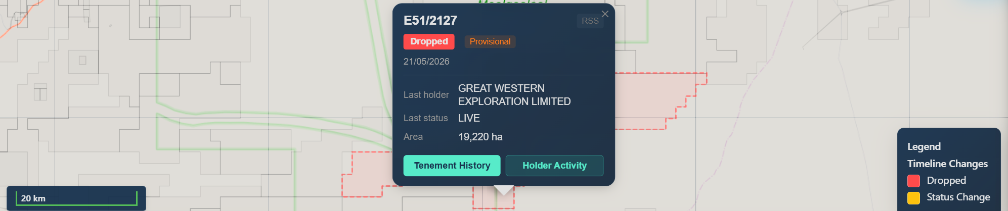
NextMaps sources these changes from both DASC data and DMPE RSS feeds, covering full surrenders and expirations, partial surrenders, and individual block releases, and displays them visually on the map as they come through. These updates may not yet be reflected in the tenement WFS layer. Instead of watching a raw feed, you get a visual picture of what's moving and an email in your inbox when something changes in your area. For anyone holding ground adjacent to active tenements, catching a partial surrender or block release early can be the difference between a competitive application and missing the window entirely.
NextMaps distinguishes between voluntary and compulsory partial surrenders. Voluntary partial surrenders are open for application immediately. Compulsory surrenders carry a release date and moratorium period before the ground becomes available. Knowing which you're looking at determines whether you need to act now or wait.
TENGRAPH vs NextMaps
Feature TENGRAPH NextMaps --------------------------- ---------- ---------- Live application visibility Yes No Expiry and surrender alerts No Yes Overnight monitoring No Yes Holder portfolio mapping Limited Yes Expenditure intelligence No Yes GIS-ready exports Limited Yes Mobile field usability Limited Yes (browser only) AI prospectivity reports No Yes
How NextMaps Fits Into the Workflow
NextMaps uses the same underlying DMPE tenure datasets as its base layer, then adds monitoring, research, and intelligence workflows on top.
Tenement alerts. NextMaps offers three alert types depending on what you're watching. Draw an area of interest to monitor new applications and changes across a region, AOI alerts check the DMPE WFS layer, so new applications typically appear within two business days of lodgement. Set a holder alert to get instant notifications when specific companies lodge applications, surrender, or withdraw tenements. Or monitor individual tenement IDs directly for instant alerts on surrenders and withdrawals. Holder and specific tenement alerts are checked continuously via RSS feed.

Holder research. Search any company holder to immediately view their full WA tenure footprint, grant timelines, expiry timelines, and spatial coverage on one map. Useful for researching ASX explorers, assessing a project area, or keeping tabs on competitor activity. Note that ASX companies often hold tenure through multiple subsidiary entities, their latest annual report is usually the best place to find the full list before searching.
Expenditure compliance layers. Tenement Intelligence layers help identify underperforming tenements, compliance risk, and potential surrender candidates. This is data that doesn't appear in standard TENGRAPH workflows and is particularly useful for explorers targeting future ground opportunities.

Datapacks. For any tenement or custom area, download a due dilligence report and bundled GIS-ready export containing tenure boundaries, drillhole collars, geochemistry, geology, and WAMEX report footprints, packaged and ready to load into QGIS, ArcGIS, or your database of choice, without the usual MTO workflow overhead.

AI prospectivity reports. For ground you're seriously considering, NextMaps can generate an AI prospectivity report and dataroom, drawing on the full WAMEX archive for that tenement or area of interest. It surfaces historical drilling results, geochemical trends, and exploration activity that would otherwise require manually reading dozens of old reports.

Frequently Asked Questions
Is it spelled TENGRAPH or tenegraph? TENGRAPH is the official spelling. "Tenegraph" is a common misspelling used on forums and search engines.
Is TENGRAPH live? For fresh applications, yes. TENGRAPH is currently the only live source because new application geometry is not immediately published through external feeds. For expirations, surrenders, and status changes, DMPE RSS feeds update rapidly and can be monitored automatically.
Is TENGRAPH the same as Mineral Titles Online? No. TENGRAPH is the mapping interface. Mineral Titles Online (MTO) handles transactions and administration, including licence management, expenditure reporting, compliance submissions, and document access. Most WA explorers use both.
Is there a TENGRAPH app? No dedicated mobile app currently exists.
How do I check mining tenements in WA? Most explorers use a combination of TENGRAPH for authoritative application checks, and monitoring platforms like NextMaps for alerts, research, and ongoing tracking.
The Bottom Line
TENGRAPH remains the authoritative source for checking newly lodged tenement applications in Western Australia. For fresh applications, nothing replaces it. But exploration workflows extend well beyond manual application checks. Monitoring expiries, tracking surrenders, researching holders, assessing expenditure compliance, exporting GIS-ready data, and catching overnight status changes all benefit from tools built for continuous monitoring and analysis.
Use TENGRAPH to verify applications. Use NextMaps to monitor everything that happens afterwards.
Track WA tenements and find ground to peg, sell or buy
NextMaps gives exploration companies and investors instant visibility over the full WA tenement landscape.
Get started →